

Quiet weekend, changes possible next week
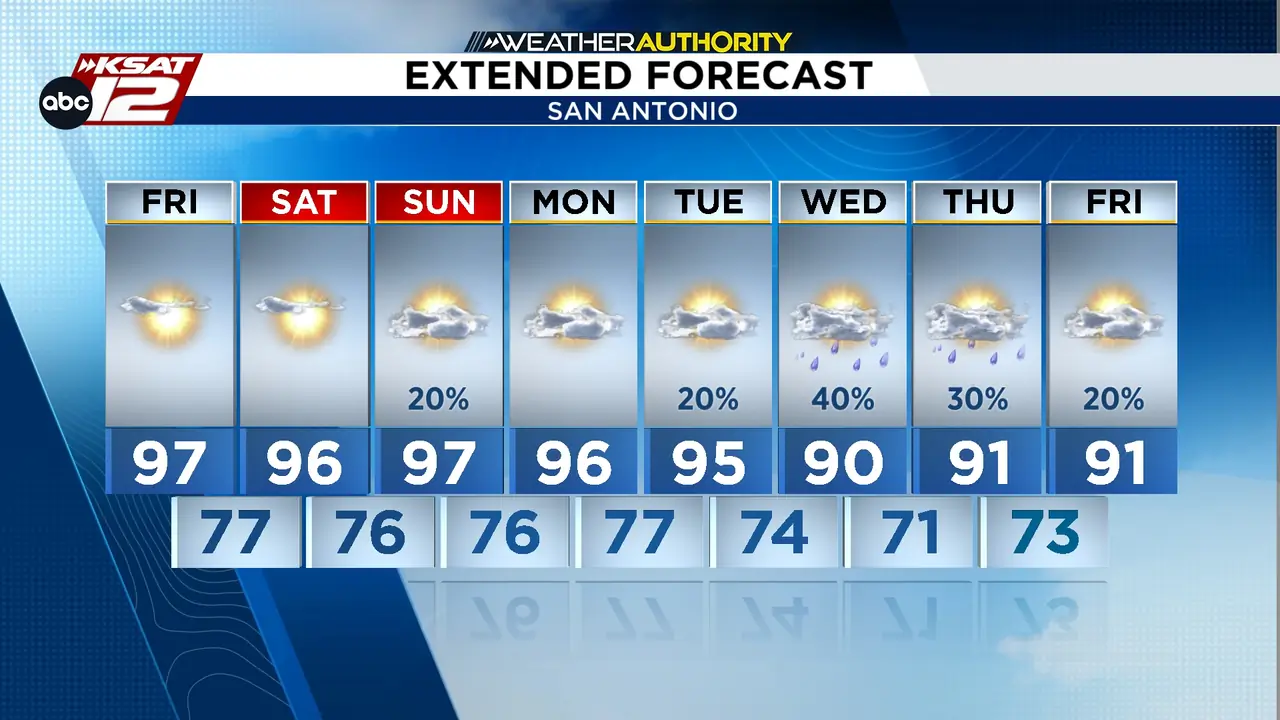
Read full article: Quiet weekend, changes possible next weekTemperatures stay above average into early next week... then, potentially some changes. Could we finally see a front? It's possible, but not a guarantee. We'll also see some added moisture from the Pacific.


Summer Heat Hangs On Through Late September
Read full article: Summer Heat Hangs On Through Late SeptemberSouth Central Texas remains stuck in a late-summer pattern with persistent heat, humidity, and little rain. Highs will stay in the mid-to-upper 90s through next week, with some areas reaching 100°.


REST OF THE WEEK: Near-record heat continues, isolated rain Thursday & Friday
Read full article: REST OF THE WEEK: Near-record heat continues, isolated rain Thursday & FridayNear-record heat continues with another day near 100°F after multiple recent 100°+ days. Deeper Gulf moisture Thursday and Friday brings more clouds, spotty rain.


High pressure keeps hot, mostly dry conditions into next week
Read full article: High pressure keeps hot, mostly dry conditions into next weekAnother day of intense heat is ahead, with temperatures climbing into the upper 90s to near 100° and heat index values potentially reaching dangerous levels. Limited rain chances will mainly favor the Coastal Plains, while most areas stay dry.

South Texas Heatwave Continues With Isolated Storms Possible
Read full article: South Texas Heatwave Continues With Isolated Storms Possible“Sweat-tember” continues across South Texas. Hot and humid conditions will dominate the weekend, with afternoon highs ranging from the upper 90s to near 106° in some locations.

FRIDAY: Spotty afternoon rain, then near 100° this weekend
Read full article: FRIDAY: Spotty afternoon rain, then near 100° this weekendAfternoon spotty rain is possible with a 30% chance between 4–8 PM, potentially causing brief lightning delays at game starts, though most areas will remain dry. The weekend will be very hot near 100°


Labor Day Weekend: Hot, Humid and a Few Spotty Showers
Read full article: Labor Day Weekend: Hot, Humid and a Few Spotty ShowersKeep your Labor Day weekend plans, but stay weather-aware. Most areas will remain dry, and temperatures should stay below 100 degrees, but the combination of heat and humidity will make it feel hotter. If you’re spending time outdoors, stay hydrated and keep an eye on changing skies, especially during the afternoon.


Hot, Sunny Weather Returns to San Antonio After Friday Night Storms
Read full article: Hot, Sunny Weather Returns to San Antonio After Friday Night StormsAfter a stormy Friday night that left widespread damage across San Antonio, hot and mostly dry weather is returning to the region. Sunshine will dominate through the weekend, with temperatures climbing back into the upper 90s and approaching 100 degrees in some areas.


High pressure system keeps South Central Texas in relentless heat wave
Read full article: High pressure system keeps South Central Texas in relentless heat waveSan Antonio is in for another scorching Sunday as a stubborn heat wave keeps temperatures at or above 100 degrees across much of South Central Texas.

Another warm weekend for San Antonio
Read full article: Another warm weekend for San AntonioSan Antonio is heading into another brutally hot August weekend, with temperatures expected to climb above 100° Saturday and Sunday. A Heat Advisory remains in effect across the northern Hill Country, the I-35 corridor and Coastal Plains through Sunday, with heat indices potentially reaching around 109°.

Very small rain chance Saturday from 3pm to 6pm
Read full article: Very small rain chance Saturday from 3pm to 6pmSaturday is expected to be the hottest day, with temperatures reaching 103° and only a slight drop in humidity during the afternoon. There is a minimal 10% chance of rain from 3pm to 6pm.


Heat Builds Across South Central Texas With Little Relief Ahead
Read full article: Heat Builds Across South Central Texas With Little Relief AheadSouth Central Texas is in for a hot and increasingly dry stretch of weather, with temperatures climbing above average Sunday and even hotter conditions expected through much of the coming week.

Pool weather this weekend with temperatures near triple digits
Read full article: Pool weather this weekend with temperatures near triple digitsSouth Central Texas is returning to hot, dry weather after brief showers, with weekend highs in the mid-90s to near 100 degrees and little chance of rain. The heat will intensify next week as a ridge of high pressure arrives keeping us toasty.

Spotty showers and non-severe storms this afternoon
Read full article: Spotty showers and non-severe storms this afternoonTemperatures will approach 100° through the weekend, with only a slight chance of afternoon showers today, especially near the coast. The upcoming week is expected to bring a prolonged stretch of even hotter weather


Hot Sunday, Steamy Back-to-School Monday; Heat Builds Through Next Week
Read full article: Hot Sunday, Steamy Back-to-School Monday; Heat Builds Through Next WeekEnjoy the last bit of the weekend, prepare for a hot first day of school, and expect the heat to become an even bigger story as the week progresses.

Hot and mostly dry weekend ahead, with heat building next week
Read full article: Hot and mostly dry weekend ahead, with heat building next weekSouth-Central Texas faces a hot and mostly dry weekend with highs in the upper 90s and only slight chances for isolated showers, mainly near the Coastal Plains. Humidity will make conditions feel even


Seasonably hot for the first week of August
Read full article: Seasonably hot for the first week of AugustThe first week of August is seasonably hot, with temperatures nearing triple digits but still better than previous years. Light wildfire smoke from Oregon and Washington is causing hazy skies over Texas, though air quality remains unaffected. Recent rainfall has led to fast-flowing rivers like the Frio and Nueces reaching some of their highest levels in years. While a heat high west of Texas keeps most rain away, a few sea breeze showers from the Gulf are possible through the weekend.

SUNDAY FORECAST: Lingering morning showers & storms south of San Antonio
Read full article: SUNDAY FORECAST: Lingering morning showers & storms south of San AntonioAfter some early morning rain south of San Antonio, most of South-Central Texas will return to hot and mostly dry conditions as drier air moves in and high pressure builds.

Storms may briefly disrupt Saturday evening in San Antonio
Read full article: Storms may briefly disrupt Saturday evening in San AntonioSouth Central Texas will get a brief break from the recent stretch of hot and dry weather Saturday as a weak front moves through the region, bringing a chance for showers and thunderstorms during the afternoon and evening. The rain window will be limited, though, with near-100-degree heat returning quickly for the rest of the weekend and into next week.

WEEKEND FORECAST: Brief window for storms Saturday between 5pm to 10pm
Read full article: WEEKEND FORECAST: Brief window for storms Saturday between 5pm to 10pmAugust begins with a brief opportunity for storms. Severe weather and flooding are unlikely, but gusty winds and brief street flooding can't be ruled out.


Nueces still flooding, slight rain chances ahead
Read full article: Nueces still flooding, slight rain chances aheadSouth Central Texas remains in a classic July pattern with a high-pressure ridge causing intense heat and dry conditions. Meanwhile, communities along the Nueces River continue managing lingering flooding from heavy rains two weeks ago.

Typical summer pattern for San Antonio, while the Nueces is still flooding from the rains 2 weeks ago...
Read full article: Typical summer pattern for San Antonio, while the Nueces is still flooding from the rains 2 weeks ago...A prolonged stretch of summer heat is settling into South-Central Texas, with temperatures trending hotter each day through the end of July.


Slowly working our way back to triple digits
Read full article: Slowly working our way back to triple digitsThe weekend brings continued sunshine and rising temperatures, reaching the mid- to upper-90s, with no rain expected. Next week, the region will see typical late-July heat, with highs near or above 100°. Flooding persists along the Nueces and Frio Rivers, with Cotulla and downstream areas remaining at major flood stage through the weekend.

Last bit of Bertha brings scattered rain
Read full article: Last bit of Bertha brings scattered rainSan Antonio faces another day of high heat with temperatures near 100°, and humidity making it feel up to 110°, while there is only a small chance of showers locally. Tropical Storm Bertha is weakening as it approaches the Texas coast, expected to bring rain mainly to coastal areas before dissipating by Friday with minimal impact. Bertha poses no significant threats to travel and will be gone by the weekend. If you have beach plans, keep them.

San Antonio hits 100° as Tropical Storm Bertha weakens over Louisiana
Read full article: San Antonio hits 100° as Tropical Storm Bertha weakens over LouisianaSan Antonio is expected to reach its first 100-degree day of 2026, with heat advisories across Texas and high humidity making conditions feel even hotter. Tropical Storm Bertha is weakening as it approaches the Louisiana coast and is expected to have minimal impact as it dissipates by Friday. Flooding continues along the Nueces and Frio Rivers, especially in Cotulla, where major flood stages persist. Local lakes and aquifers are at their highest levels in four years, with Choke Canyon and Lake Corpus Christi anticipated to rise soon from recent floodwaters.

Tropical Storm Bertha update, and the Nueces is flooding downstream
Read full article: Tropical Storm Bertha update, and the Nueces is flooding downstreamTropical Storm Bertha, now with 60 mph winds, will impact Louisiana but is expected to weaken and bring only minimal rain to Texas, while San Antonio faces its first triple-digit temperatures of the year.

Near 100° for San Antonio this week, and Tropical Storm Bertha
Read full article: Near 100° for San Antonio this week, and Tropical Storm BerthaTemperatures are forecast to rise to near 100 this week, while we watch what unfolds with a tropical system in the Gulf. At this time, we believe impacts to South Texas will be minimal.

Seasonable with Heat indices near 100 as dry weather holds
Read full article: Seasonable with Heat indices near 100 as dry weather holdsRivers remain above flood stage from recent historic rainfall, while lake levels continue to rise as the Edwards Aquifer recharges; the week ahead will be dry and increasingly hot, with possible heat advisories by midweek.

Flood threat shifts downstream as rain ends, heat returns next week
Read full article: Flood threat shifts downstream as rain ends, heat returns next weekThe historic rainfall event is over, but the flood story is not. River flooding will remain the primary concern through the weekend and into next week as high water continues to move downstream. At the same time, South Central Texas is transitioning back to a familiar summer pattern, dry weather, increasing sunshine and building heat.


⚠️DON’T LET YOUR GUARD DOWN⚠️: More rounds of flooding rain likely through Thursday
Read full article: ⚠️DON’T LET YOUR GUARD DOWN⚠️: More rounds of flooding rain likely through ThursdayFlash flood warnings remain in effect across several South Texas counties, with some areas experiencing over a foot of rainfall and ongoing street and river flooding. Residents, especially those near creeks and rivers, are urged to monitor water levels as additional rounds of heavy rain are expected through Wednesday, increasing the risk of further flooding. The flash flood watch continues until Thursday, with the heaviest rain shifting west toward the Rio Grande before conditions improve by the weekend. Caution is advised for commuters and those in flood-prone regions.

FLOOD RISK THIS WEEK: Rounds of heavy rain tonight through Friday morning
Read full article: FLOOD RISK THIS WEEK: Rounds of heavy rain tonight through Friday morningRainfall totals may reach 3-6 inches, with isolated areas near the Rio Grande and Edwards Plateau seeing more than 8 inches, potentially affecting the Frio, Nueces, and Rio Grande rivers.

Gulf moisture fuels daily rain chances through midweek
Read full article: Gulf moisture fuels daily rain chances through midweekStarting Monday, Gulf moisture will bring daily rain and thunderstorms through midweek, with the highest risk of heavy rainfall and minor flooding on Tuesday and Wednesday before drier weather returns by week's end.

Scattered Downpours Return This Weekend
Read full article: Scattered Downpours Return This WeekendThe upcoming pattern should help keep extreme heat in check while providing beneficial rainfall—though some neighborhoods could see brief flooding concerns during heavier storms. Keep the umbrella close and stay weather-aware throughout the weekend.


Not your typical July weather: rain
Read full article: Not your typical July weather: rainFriday and Saturday bring increased humidity and scattered, heavy downpours that may cause minor street flooding, though rain will be spotty and not persistent. Early next week remains unsettled with continued afternoon rain chances and possible street flooding, but overall this is considered a favorable forecast for this typically hot and dry period.


Spotty downpours for afternoon commute, but better rain chances over the weekend
Read full article: Spotty downpours for afternoon commute, but better rain chances over the weekendSpotty downpours may affect the evening commute with brief heavy rain and lightning, though most areas will remain dry. Dry weather returns Wednesday and Thursday, accompanied by light Saharan dust causing hazy skies but minimal impacts. Rain chances increase over the weekend, with scattered downpours likely Saturday afternoon due to Gulf moisture, though rain will not persist all day.

THIS WEEK: Hot, but tolerable with increasing rain chances by the weekend
Read full article: THIS WEEK: Hot, but tolerable with increasing rain chances by the weekendRain chances increase by the weekend, with a surge of Gulf moisture bringing clouds and potential heavy downpours, especially on Saturday.

Seasonable July weather in South-Central Texas
Read full article: Seasonable July weather in South-Central TexasSouth-Central Texas will see typical early July weather, with hot temperatures in the mid-90s. The best rain and thunderstorm chances are expected Monday afternoon and evening, mainly in the Hill Country. High pressure will then bring hotter, drier conditions midweek, with highs nearing the upper 90s.

Fantastic weather for firework shows
Read full article: Fantastic weather for firework showsEvening temperatures won't fall out of the 90s until closer to 9 PM. Hot and dry weather pretty much repeats itself through Tuesday. Afternoon temperatures become slightly warmer through the back half of next week.

Hot, humid, and rain-free 4th of July 🎆
Read full article: Hot, humid, and rain-free 4th of July 🎆San Antonio and much of Texas will experience hot, humid, and mostly rain-free weather for the 4th of July holiday weekend, with only a very low chance of stray showers. Fireworks celebrations are expected to proceed under seasonable conditions, but caution is advised for those using personal fireworks due to drying grasses and the risk of grass fires. Rain chances remain low through Sunday and Monday, with only isolated storm activity possible.

New York has hit 100° this year before San Antonio! Plus: Your July 4th forecast
Read full article: New York has hit 100° this year before San Antonio! Plus: Your July 4th forecastSouth Central Texas will experience seasonable temperatures in the low- to mid-90s this holiday weekend, with only a slight chance of spotty showers or storms, mainly around sunrise and late afternoon. Rain is unlikely to impact fireworks Saturday night, though it will be breezy with gusts up to 20 mph from the south. Rain chances increase slightly to 20% on Sunday and Monday due to outflow boundaries from the north, but dry conditions return after Monday. Meanwhile, the Northeast faces more intense heat with temperatures exceeding 100 degrees.


Hot, but not *too* hot as we approach 4th of July
Read full article: Hot, but not *too* hot as we approach 4th of JulyHot, sunny weather continues through the 4th of July with highs in the 90s and a heat index near 100°; only a slim chance of a brief coastal shower each day. Fireworks displays will be breezy and warm, and caution is advised due to wind. Rain chances may increase slightly Sunday into Monday if a weak low pressure system develops nearby.

Yes, it’s hot! But here’s the thing: it could be a lot worse...
Read full article: Yes, it’s hot! But here’s the thing: it could be a lot worse...Temperatures in the San Antonio area are expected to remain in the low- to mid-90s, with a heat index near 100°, which is typical for this time of year. Skies will be less hazy as Saharan dust clears, and while the chance of coastal showers reaching the metro is just 10%, those closer to the coast may see brief rain. July 4th will be toasty, humid, and sunny, with evening temperatures dropping into the 80s and a southeast breeze. Overall, the weather remains seasonally average with few exceptional events.

Hot & dry pattern continues to Start July
Read full article: Hot & dry pattern continues to Start JulySouth-Central Texas will continue experiencing hot, dry conditions into early July. High pressure will keep rain chances very low, and only isolated showers are possible later in the week near the Coastal Plains. The summer heat remains the main concern, especially for outdoor activities. Independence Day is expected to be mostly sunny, hot, and dry, making it favorable for celebrations but requiring precautions against heat.

San Antonio Braces for Saharan Dust and Hazy Skies
Read full article: San Antonio Braces for Saharan Dust and Hazy SkiesSan Antonio will experience sunny skies and temperatures in the mid 90s, with highs reaching 93 degrees. Hazy conditions are expected by Sunday evening due to the arrival of Saharan Dust, peaking Monday afternoon and clearing by Tuesday. Rain chances may return later in the week as high pressure moves east. Residents are advised to use sunscreen when outdoors.


Happy Father’s Day & First Day of Summer!
Read full article: Happy Father’s Day & First Day of Summer!Father’s Day in South Central Texas starts with a few spotty showers, but most areas remain dry as heat and humidity build, with highs in the upper 80s to mid 90s and heat index values reaching up to 108.

Heavy rain and thunderstorms no longer in the forecast for San Antonio
Read full article: Heavy rain and thunderstorms no longer in the forecast for San AntonioSan Antonio experienced heavy rain and thunderstorms, with some areas receiving over 2 inches. Storms are expected to continue through sunrise, maintaining a risk of additional flooding. Scattered showers and storms remain possible into the afternoon, but a drying trend is expected by Sunday as high pressure builds.

